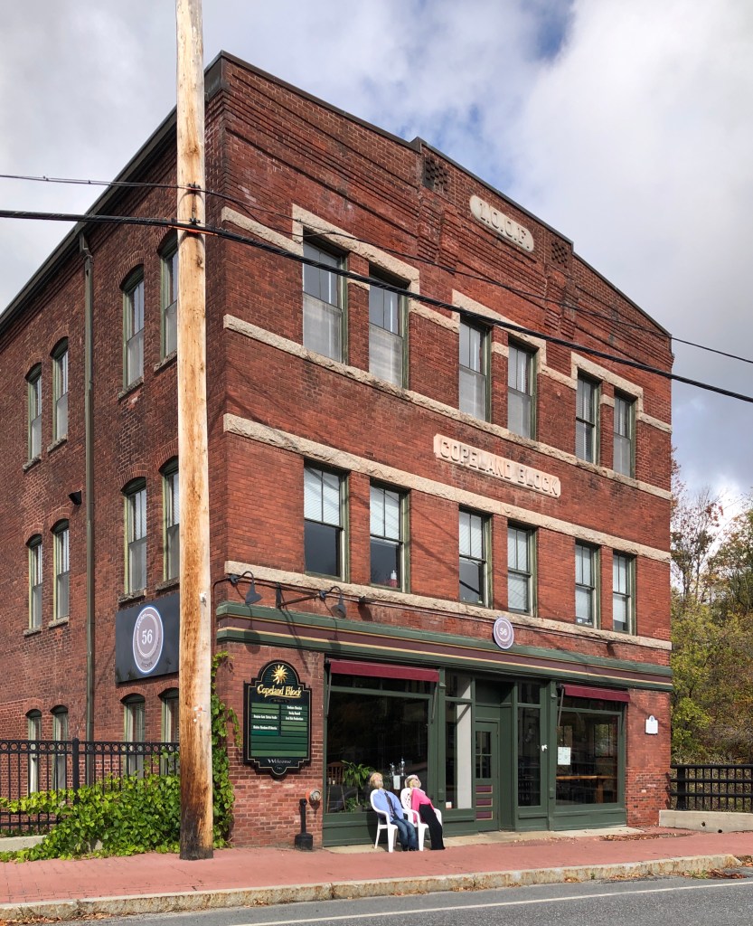
The Copeland Block is Enfield’s only brick commercial block. It is located on the bank of the river which cuts through the village and terminates at Mascoma Lake. Ira Copeland built the block for $10,000, during the final years of his life. He had lived in Enfield since 1853. He and his wife Elsina lived on her parent’s farm on Shaker Hill for many years. After her death in 1897, he abruptly moved to town, moved into a home on Depot Street, and built this commercial block with his lasting money. He died just years later. The Copeland Block contained a dmgstore, millinery shop and offices over its history, with an I.O.O.F. meeting space upstairs.
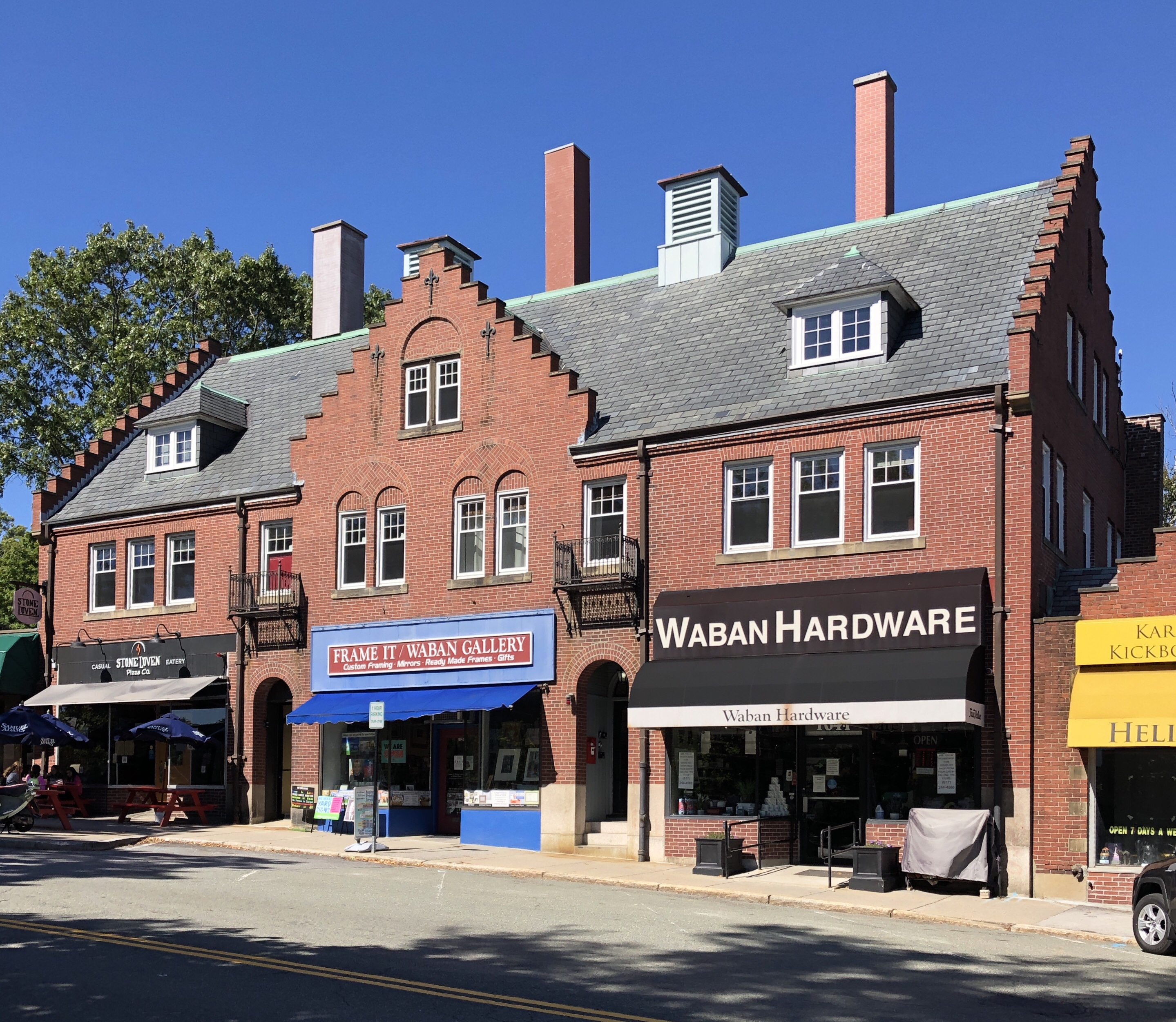
William C. Strong, a prominent local citizen who resided nearby, had this stylish commercial block built to serve the expanding population of the village which eventually became known as Waban. After the completion of the Waban Train Station, the demand for neighborhood retail became apparent and William Strong was an early developer to realize this. He hired Lewis Bacon, an architect who resided nearby, to design the commercial block. The result is a stunning Dutch Revival building with gables showcasing stepped parapets. The upper stories were apparently used as apartments when completed. Notwithstanding Strong’s efforts, the Waban commercial district developed rather slowly. It was not until 1924 that the row of one-story shops was added to its right. The addition was designed by Edward B. Stratton, who followed suit with Tudor and Jacobean motifs, to compliment the Dutch Revival block.
Constructed for the Woman’s Home Missionary Society of the Methodist Church of New England, this building was associated with the Hull Street Medical Mission from the time of its construction, in 1901, to about 1950. The mission was one of a number of church-related social service programs established in the North End in the late 19th and early 20th centuries to address the needs of recent immigrants, namely the Russian Jews, Italians, and Portuguese residing in this area of the neighborhood. In 1909-1910 alone, 14,574 treatments were given in the clinic, providing a huge medical service to the widely low-income immigrant community of the North End [29th Annual Report, 154]. The Medical Mission closed in the early 1950s and the property was later sold and converted to apartments. It was designed by architect Walter Forbush, who utilized ogee arches and leaded glass windows, adding much flair to the building’s design.
It is impossible to overstate the significance of the railroad in the 19th century to the industrial growth and economy of New England and American cities. In order to connect Boston and its ports to the Hudson Valley in New York, a western rail line was constructed in the southern part of Massachusetts but was not an ideal route. In response, businessmen and politicians began to envision a more direct rail line across Massachusetts, but with one problem: trains hate climbing mountains! Instead of going around Hoosac Mountain, a massive detour, engineers thought they could tunnel through it, and that’s what they did, creating the Hoosac Tunnel. The tunnel through Hoosac Mountain is just under 5 miles long. Its active construction period consumed roughly a quarter-century and cost at least $17 million in 1870s dollars – an enormous sum. The cost was paid in dollars and the lives of nearly 200 miners (many of whom suffered terrible deaths as you can imagine). The first train passed through the tunnel in 1875, with the eastern portal wall constructed in 1877 (seen here). By 1895, roughly 60% of Boston’s exports traveled through the tunnel. Since then, some small collapses and deferred maintenance have left their mark on the tunnel, though it is still in operation today!
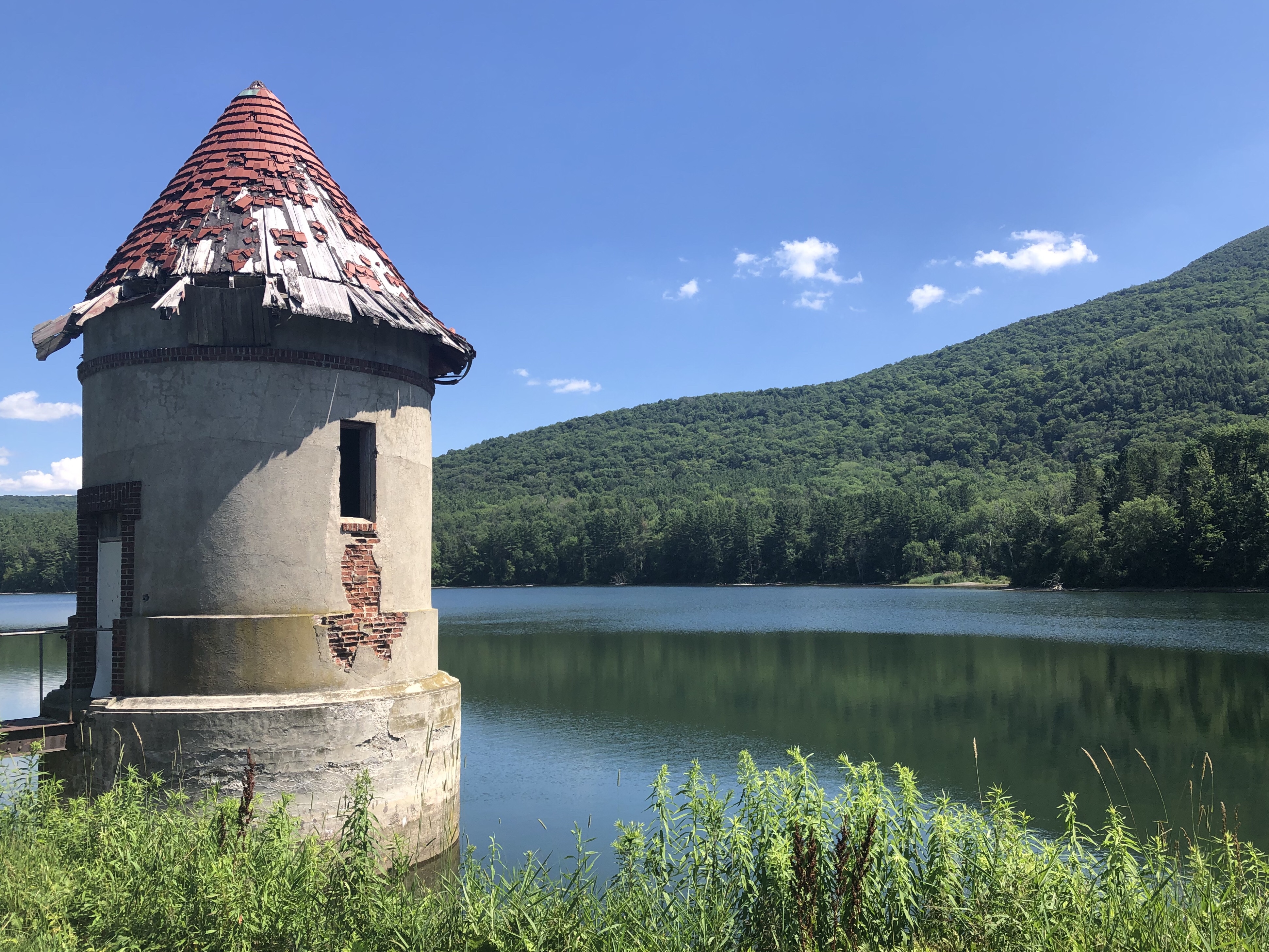
An adequate water supply for the residents and industry of North Adams was from the late 19th century, an issue of paramount importance to residents. For the next several decades the population grew at such a high rate that a reservoir was required, and in 1914, the Mount Williams Reservoir was planned and constructed. Land was selected where a small Brook passed through and a concrete core dam was designed and built that year to impound the brook. At the waters edge, a gatehouse, once perched upon the shore like a castle, is decaying. The gatehouse is a cylindrical brick structure clad in stucco, capped with a red tiled conical roof. The structure remains active to this day with a more modern structure nearby providing support to North Adams’ waterworks system.
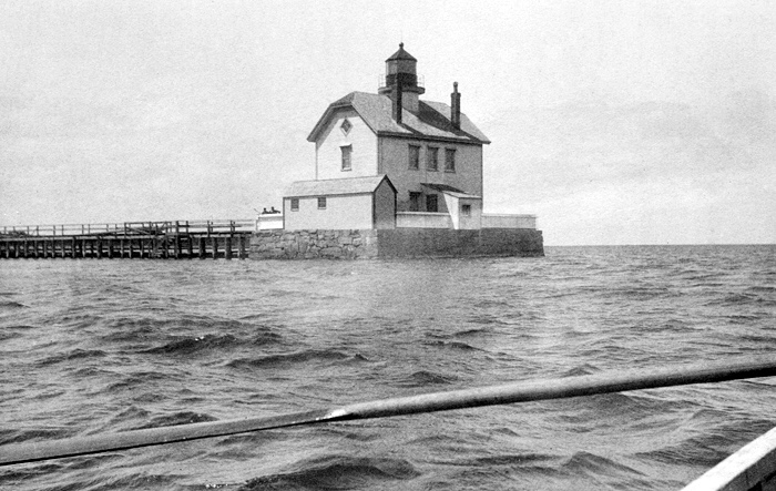
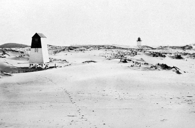
Pre-1939 image of original lighthouse with walkway to the left.
With Edgartown being synonymous with the whaling and the ocean, its obvious the town has long had a lighthouse to guide weary travellers. In 1828, Congress approved $5,500 for “building a pier and light-house on the Point of Flats, at the entrance to Edgartown Harbor.” That first lighthouse was a two-story dwelling with a side-gabled roof atop which was centered the lantern room. The structure was erected on wooden pilings out in the water, requiring its first keeper to row a short distance to get to the tower. In 1830, a 1,500-foot-long wooden walkway was built at a cost of $2,500 to connect the lighthouse to the shore. In 1840, the rotten wooden pilings supporting the lighthouse were replaced by a stone pier. The keeper’s house was drafty and leaky, and vulnerable to the sea and weather due to its exposed location. This resulted in a greater than average turnover of keepers, and some keepers refused to live in the official quarters preferring to seek lodging on the nearby shore. The lighthouse was restored numerous times through the early 20th century until The Great Hurricane of 1938 inflicted significant damage to the lighthouse. Upon taking control of the nation’s lighthouses in 1939, the U.S. Coast Guard quickly tore down the building.
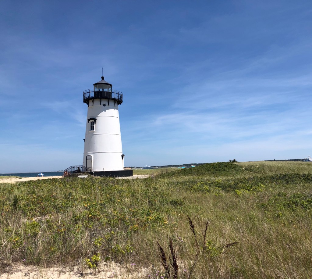
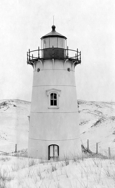
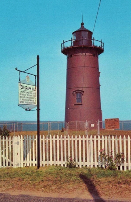
The original plan was to replace the lighthouse with a steel skeleton tower, but instead a disused 1881 lighthouse that served as a rear range light on Crane’s Beach in Ipswich, Massachusetts was dismantled and barged, minus its brick lining, to Edgartown. The relocated forty-five-foot cast-iron tower was soon in service at Edgartown and remains an active aid to navigation today, showing an automated flashing red light every six seconds. The lighthouse remains a must-see spot when visiting Edgartown.
Is anything more “New England” than a historic lighthouse? Whenever I think of symbols of New England, lighthouses, Saltbox colonial homes, and lobster comes to mind. Located just north of Oak Bluffs, the East Chop Light was built to guide the hundreds of ferries every summer, picking up and dropping off passengers to the island. One of the many definitions of “chop” is the entranceway into a body of water. Knowing this, it seems natural that the two lighthouses flanking the entrance to the harbor at Vineyard Haven on the north shore of Martha’s Vineyard are respectively known as East Chop Lighthouse and West Chop Lighthouse. In 1878, a one-and-a-half-story dwelling and a cast-iron tower were under construction at the station. The forty-foot-tall, conical tower was similar in style to several other New England lighthouses constructed during the late 1800s. The lighthouse was painted white at first, but in the 1880s it received a coat of reddish-brown paint and became popularly known as the “Chocolate Lighthouse.” In 1988, it was returned back to white, as the dark color was causing excessive heat and condensation in the tower. East Chop Lighthouse remains an active aid to navigation, although the Fresnel lens was replaced by a modern beacon in 1984. The land surrounding the tower was sold to the town of Oak Bluffs in 1957 for use as a park.
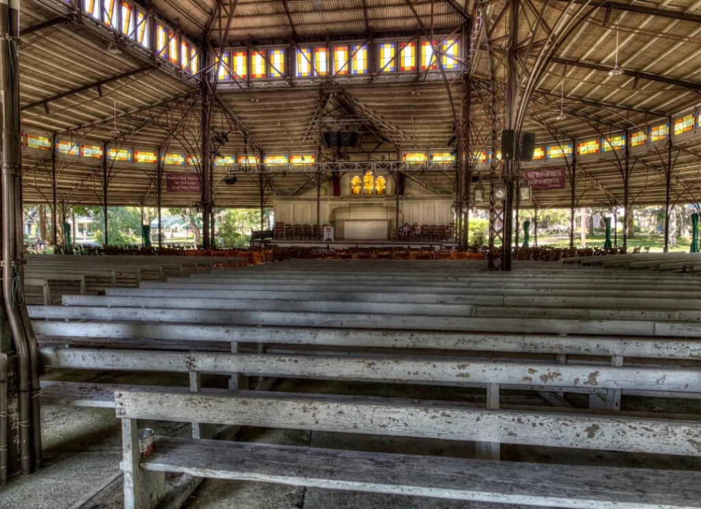
The year after Trinity Methodist Church was constructed, the Martha’s Vineyard Camp Meeting Association at Wesleyan Grove, built the wrought-iron Tabernacle, the most significant single building in the campground. The beautiful iron Tabernacle, which seats over 2,000, was designed and built in 1879 by John W. Hoyt of Springfield, Massachusetts. The building was completed in less than four months after the contract was signed. The Tabernacle covers the original consecrated ground of 1835 where the first Methodists erected canvas tents to worship under the trees. By 1869, the attendees at the revival meetings needed more protection from the sun and rain because the large oaks that had attracted the founders 35 years before had begun to die. Since 1870, the Association erected a mammoth canvas tent supported on tall poles every summer. The tent proved unsatisfactory because of ventilation problems and a tendency to collapse in storms. In 1878 the Association solicited designs for a large wooden tabernacle a building of vast roofs, minimal supports, and open walls. The plans it received, which were elaborate versions of the wooden tabernacles or “arbors” of southern camp meetings, proved too expensive to build on this site. Campground resident John W. Hoyt solved the problem with a much cheaper wrought iron structure that was largely prefabricated and could be speedily erected on the uneven site. The gorgeous Victorian Gothic tabernacle remains today as the centerpiece of the Wesleyan Grove National Historic Landmark District, an esteemed historical designation.
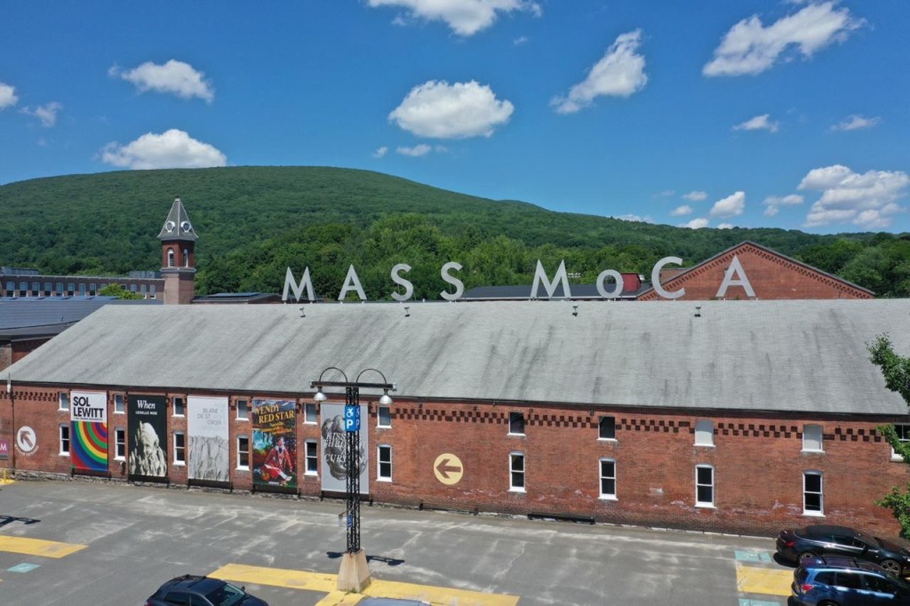
On a last-minute trip to the Berkshires, I couldn’t help but stop at the recently re-opened Massachusetts Museum of Contemporary Art (Mass MoCA) in North Adams. Being a huge nerd for industrial history and repurposed mills and factories, it was an absolute treat to walk through the large brick and steel buildings and wings lined with steel casement windows providing the perfect scenery for some amazing artworks. What is now known as Mass MoCA, – one of the premier art museums in New England – was once Arnold Print Works, a one time world leader in textile manufacturing with offices in New York City and Paris.
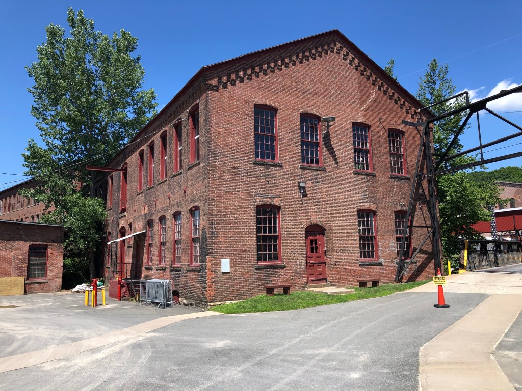
The Arnold Print Works were built on the Hoosac River near the center of North Adams. The company was the town’s largest industry during the city’s economic heyday from the Civil War until the early 20th century. The company was founded in 1861 by the John, Oliver, and Harvey Arnold, who began production of printed cloth at an existing cotton mill. At the dawn of the American Civil War, the newly formed company became flush with money due to government contracts for manufacturing Union Army uniforms. The company expanded after the war until a fire destroyed nearly all of the wooden buildings on the site. After the fire, a majority share of the company was purchased by Albert Charles Houghton, who became the first mayor of North Adams, and he oversaw the expansion and prosperity of the company, starting with new buildings of fire-proof construction.
By the early 20th century, many textile and cotton manufacturing shifted to the American South severely crippling the mill’s profits. In 1929, Sprague Electric Company moved to North Adams from Quincy, Massachusetts, and began buying the Arnold Print Works buildings. The print works moved much of its operation to nearby Adams and concentrated on a few particular products in its North Adams plant. The print works was finally sold in 1942 for just $1.9 million dollars, a far departure from its once prosperous past. The plant was shortly thereafter acquired by Sprague Electric Company.
While largely leaving the building exteriors as they were, Sprague made extensive modifications to the interiors to convert the former textile mill into an electronics plant. Sprague physicists, chemists, electrical engineers, and skilled technicians were called upon by the U.S. government during World War II to design and manufacture crucial components of some of its most advanced high-tech weapons systems, including the atomic bomb.
[Outfitted with state-of-the-art equipment, Sprague was a major research and development center, conducting studies on the nature of electricity and semi-conducting materials. After the war, Sprague’s products were used in the launch systems for Gemini moon missions, and by 1966 Sprague employed 4,137 workers in a community of 18,000, existing almost as a city within a city. From the post-war years to the mid-1980s Sprague produced electrical components for the booming consumer electronics market, but competition from lower-priced components produced abroad led to declining sales and, in 1985, the company closed its operations on Marshall Street.] (Mass MoCA History)
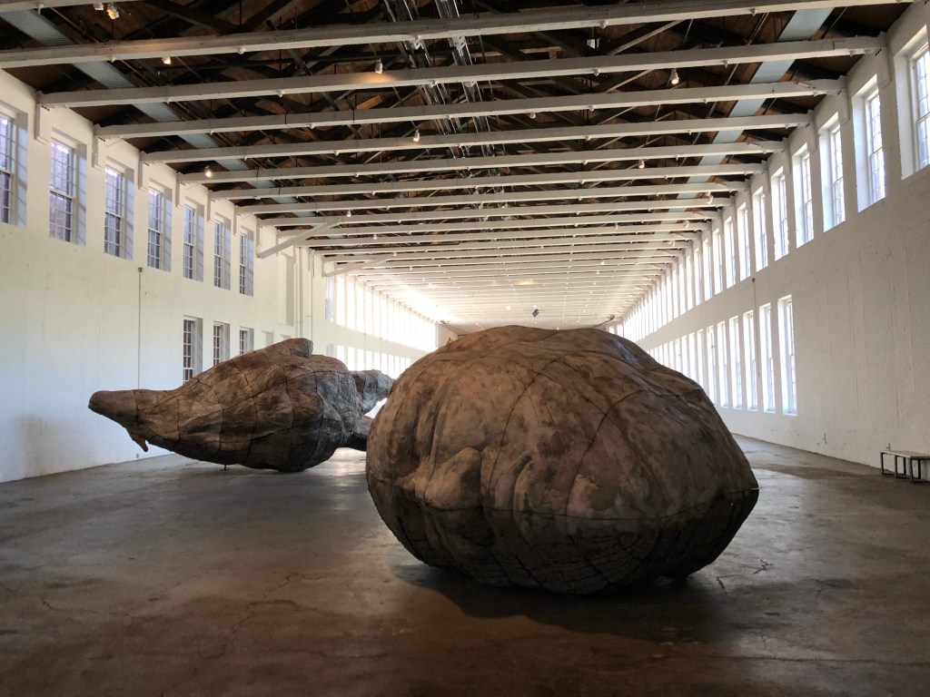
The complex sat vacant briefly before the Williams College Museum of Art, led by its director, Thomas Krens—who would later become Director of the Solomon R. Guggenheim Museum—advocated for a museum space for contemporary art that would not fit in traditional art galleries. The nearby Arnold Mills seemed like a perfect, yet daunting task to repurpose. Bruner/Cott Architects of Cambridge were hired to repurpose the mills and oversee the massive adaptive reuse project which today totals nearly 300,000 square feet of galleries and art venues.
One of the more unique summer cottages in Kennebunkport is the Talbot Cottage, a ca.1890 eclectic Shingle style home. The home features curvilinear Flemish gables crowned with ball finials, diamond paned windows, gabled dormers with finials and pendants, and a wrap-around Colonial Revival porch with fluted columns. The stunning home was built for Julian Talbot, of the Talbot Family who ran a mill in Lowell, MA. The home was soon after sold to George Hubbard Clapp, a Pittsburgh pioneer in the American aluminum industry, who summered in Kennebunkport.


