Happy Hollow Siphon House, Weston Aqueduct // 1903

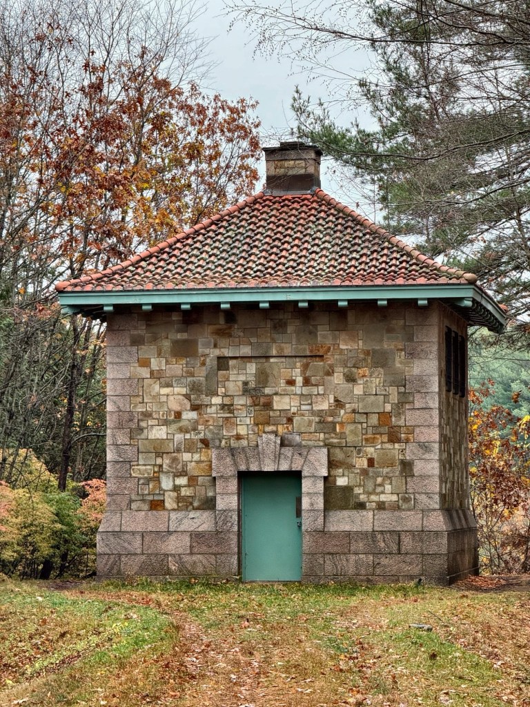
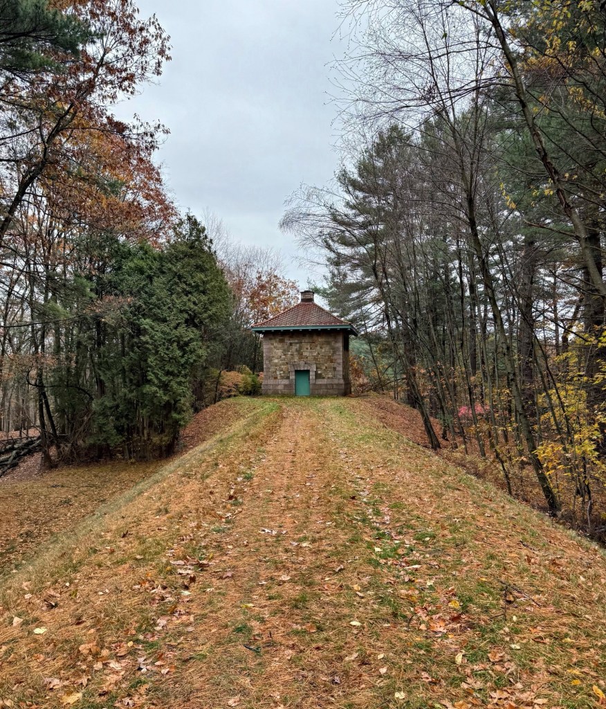
The Weston Aqueduct was designed to deliver water from the Sudbury Reservoir in Framingham to the Weston Reservoir in Weston, Massachusetts. Built between 1901 and 1903, the aqueduct was designed to provide water to the suburbs north of Boston. All of the buildings that shelter the aqueducts above-ground elements, including this structure in Wayland, were designed by the architectural firm of  Shepley, Rutan and Coolidge, with landscaping along the route and at the reservoir designed by the Olmsted Brothers, landscape architects. This siphon house, known as the Happy Hollow Siphon House was built in 1903 and was an important part of the aqueduct system, as it transferred water through varied elevations using gravity and pressure to move the liquid without a pump. The aqueduct route is now a long, linear path and remains owned by the Massachusetts Water Resource Authority.

Kingston Waterworks Pumphouse // 1888

The Queen Anne style pumphouse of the Kingston Waterworks in Kingston, Massachusetts, is a unique brick building capped with a hipped roof and wood shingle tower over the arched entrance, surmounted by a bell-cast metal roof. The structure was built in 1888 from plans by Quincy Adams Faunce, a mason, who likely worked with an architect to design the building. Before the building was completed, residents had to pump and transport their own water. This was until the first private Kingston Aqueduct Company formed, when householders of means bought stock in the company. The Aqueduct Company used a natural spring near a local pond. Before the waterworks, water was piped through the village through hollowed logs with their joints covered with iron bands. The building remains a well-preserved and significant structure that allowed Kingston to grow from a sleepy agricultural town to a vibrant community.

Salem Water Company Offices // 1879

Salem, Massachusetts, was first settled by Europeans in 1626, and it would take 170 years until in 1796, an organization of citizens was established for the purpose of supplying the inhabitants generally of Salem and Danvers with pure spring water. The Salem and Danvers Aqueduct Company was incorporated in 1797  “for the purpose of conveying fresh water by subterraneous pipes into the towns of Salem & Danvers.” As Salem grew, the need for a more central water district and distribution network became a necessity for the health and prosperity of the city. A 1864 law allowed Salem to construct its own water works, and it formed a Board of Water Commissioners who designed and constructed the system. From this, funding was acquired and paid for the laying of tens of thousands of feet of subterranean water distribution pipes connecting the reservoir to buildings and hydrants in Salem. Offices of the Waterworks were scattered and obsolete until 1877, when funds for the construction of this structure at 32-34 Church Street were set aside as the new Water Department Offices. Completed by 1879, the building is a great example of a Romanesque/Italianate style masonry structure with corbelled cornice and arched openings. According to the city directories, this building continued to operate as the Salem Water Works into the late 1930s. By 1945, it was the headquarters of the United States War Price & Rationing Board. In 1964, it held a number of city offices including: Civil Defense headquarters, Fire Department headquarters, Licensing Board, Planning Board, and the City Veterans Service, before being sold by the City of Salem to private ownership in 1976.

Spot Pond Gatehouse // 1900

The Middlesex Reservoir and Spot Pond are located just north of Boston and have long been a little piece of the outdoors near the heart of New England’s largest metropolitan area. In 1894, the Massachusetts Legislature established the Metropolitan Parks Commission, which was endowed with the authority to acquire, maintain, and make recreational spaces available to the public. By 1900 the new commission had acquired 1,881 acres for the reservation. Part of this reservation, Spot Pond, is a natural water feature that for a number of years was integrated into the Boston area public drinking water supply, servicing the towns of Stoneham, Melrose, and Malden with drinking water. As part of this, gatehouses were built with hardware to open and close the pipes delivering the water to the adjacent towns. This gatehouse is in Stoneham was built in 1900 by the architectural firm of Shepley, Rutan & Coolidge, to not only protect the machinery inside, but to beautify the parkland, then maintained by the Metropolitan Parks Commission. The Renaissance Revival style building is today surrounded by a tall chain link fence, which really diminishes its presence in the landscape (but it does help prevent graffiti).

Beacon Hill Reservoir // 1849-1883

Did you know there was once a massive granite reservoir in Beacon Hill?

Long before the Wachusett and Quabbin Reservoirs that now supply water to Boston, the city’s original municipal water supply was Lake Cochituate, a reservoir in Metro-west. Due to Beacon Hill’s high elevation, the city selected the site behind the recently completed Massachusetts State House, to store and distribute water to the city. The site was too steep, so it had to be graded. Therefore, the top of Beacon Hill, where the beacon had long been standing, needed to be lowered to accommodate the reservoir. The soil was dug by hand and hauled by cart down to fill the old Mill Dam in the Bulfinch Triangle area. The reservoir, which opened in 1849, was unique in its approach. The design of the structure needed to minimize its footprint and reflect well on its surroundings in the prestigious location. In lieu of earthen bermed walls, as was the convention in most period distribution reservoirs, the design chose to create a watertight tank within a masonry structure. This made the structure the first elevated storage tank constructed in New England. Sheet lead was used to make the reservoir watertight (which likely led to a lot of health issues (hindsight is 20/20). By 1870, the poor water pressure made the Boston Waterworks build the Roxbury Standpipe, which relegated the Beacon Hill Reservoir to being an emergency water source for use only in case of fire or accident to the pumping-mains. In 1883, Boston Water Works sold the structure to the Commonwealth, who demolished it for the addition to the State House.

Fort Revere Tower // 1903

The Town of Hull, Massachusetts was first settled in 1622 and officially incorporated in 1644, when it was named for Kingston upon Hull, England. The town juts out into the Boston Harbor, which historically had provided as a defense for approaching vessels into the harbor. As early as 1673, Telegraph Hill in Hull, was used as the highest point in the Boston harbor area from which signals could be sent warning the approach of vessels. The site was first used as a fort in 1776 to defend the port of Boston. Fort Independence was built on top of the hill in 1776-1777, to be succeeded by the much larger Fort Revere in 1903 (see next post). The first telegraph tower was built on the hill in 1827. Several other telegraph stations later occupied the site until 1938, when radio communications made the site obsolete. Though little of the original Revolutionary-era fort remains, the fort which began construction at the turn of the 20th century lasts as a stunning reminder to the importance of coastal defenses, high atop hills. At the highest point of Telegraph Hill this water tower which rises 120 feet off the ground was built in 1903 for the new Fort Revere as the first reinforced concrete water tower in the United States. At the top of the tower, an observation deck (now closed) was also used to send messages to other harbor defenses. The tower was restored in 1975 was designated an American Water Landmark in 2003. It was periodically open to the public until mid-2012 when it was closed due to safety concerns.

Mount Williams Reservoir Gatehouse // 1914

An adequate water supply for the residents and industry of North Adams was from the late 19th century, an issue of paramount importance to residents. For the next several decades the population grew at such a high rate that a reservoir was required, and in 1914, the Mount Williams Reservoir was planned and constructed. Land was selected where a small Brook passed through and a concrete core dam was designed and built that year to impound the brook. At the waters edge, a gatehouse, once perched upon the shore like a castle, is decaying. The gatehouse is a cylindrical brick structure clad in stucco, capped with a red tiled conical roof. The structure remains active to this day with a more modern structure nearby providing support to North Adams’ waterworks system.

Echo Bridge // 1876

Spanning the Charles River between Upper Falls Village in Newton and Needham, the Echo Bridge, is one of the most stunning structures around Boston. While not technically a building, I couldn’t help but share one of my favorite off-the-grid places to explore in the region.

The bridge served as crossing for water to be transported from the Sudbury River to the growing City of Boston. The entire aqueduct transported water over 18 miles from Farm Pond in Framingham and was stored in the Chestnut Hill Reservoir in Boston. Due to the topography of Hemlock Gorge in Newton, a large elevated bridge was required, creating one of the biggest engineering marvels around Boston. George W. Phelps, a contractor from Springfield, MA was selected as the builder of the bridge with a low bid. The 500′ bridge features a total of seven arches, with the largest spanning the Charles River being 137′, the second largest masonry arch span in the U.S. upon its completion.

Echo Bridge is constructed of large granite block and brick, which was held in place by wooden framework until the arches would be able to support their own weight at the top of the arches. Echo Bridge gets its name from the acoustical phenomenon when you stand at the base of the arch at the river and when speaking, the sound reverberates and echoes back and forth.