Wrentham State School // 1910

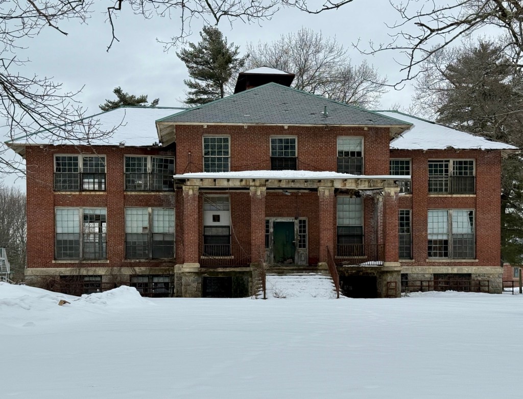
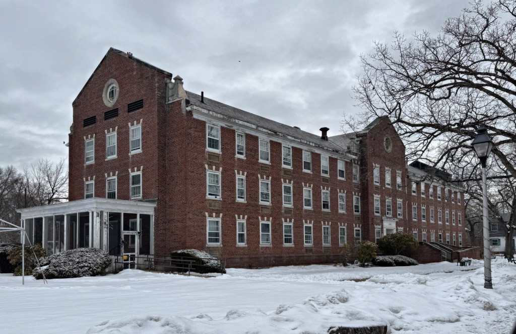
The Wrentham State School (also known as the Wrentham State Hospital) was authorized in 1906 as a school for the “feeble-minded”, and the campus is comprised of a few dozen buildings largely from the early to mid 20th century. The school was founded to house and treat developmentally disabled children and was the first in the state of Massachusetts to employ a standardized plan for wards and employee housing. A site occupied by farmhouses just north of Wrentham Center was selected and purchased by the Commonwealth of Massachusetts. The school officially opened in 1910 and brick structures were built to house students and workers. In its first year, 217 pupils were admitted to the facility, roughly half boys and girls. A majority of the early ward buildings were constructed in the early years of the school, with most designed by the Boston architectural firm of Kendall, Taylor & Stevens, who also designed many other similar facilities around the country in the early 20th century. Most buildings are examples of the Arts & Crafts and Colonial Revival styles built of brick. Today, the campus is comprised of roughly half, deteriorating historic buildings and half are used as part of the Wrentham Developmental Center, which continues the important (and under-funded) work of treating psychiatric and developmental disorders of patients.

Hopedale Village Cemetery Tool House // 1894

At the heart of the Hopedale Village Cemetery, this diminutive historic tool shed and office showcases that even for functional buildings set within a cemetery, high-quality materials and good design can enhance the landscape. The cemetery was laid out in 1845 in connection with Hopedale’s Utopian settlement, but expanded later in the 19th century as a formal landscaped cemetery in about 1887. The growth and investment of the cemetery coincides with the growth of the community as it prospered with the success of the Draper Corporation factories in town. Landscape architect, Warren Henry Manning updated the landscape here, with scenic vistas and hills, which followed the popular Rural cemetery movement of the 19th century. The cemetery contains many graves and mausoleums of the wealthy factory managers and benefactors of the community, which dot the sprawling landscape. In 1894, architect, Robert Allen Cook, designed this stone tool shed, which may have also contained a small office with cemetery records. The one-story, hip-roofed building features rough rubblestone walls with an eyebrow dormer centered on the façade, and has been preserved by the community for well over 100 years.

Wooster Memorial Chapel, Fountain Hill Cemetery // 1915

Located in Fountain Hill Cemetery, which has become a sort of Rural Cemetery in the small town of Deep River, Connecticut, this handsome gothic chapel graces the entrance and has provided a place of solemn memorials and celebrations of life for over 100 years. The Fountain Hill Cemetery was originally established in 1851, but after a half-century of use, Miss Mary McCellan Wooster (1839-1911), sought a non-denominational chapel for the grounds to not only beautify the local cemetery, but provide a place to honor the dead. In her will, Miss Wooster left $10,000 for a new chapel. The cemetery board of directors hired architect, Isaac Allen, Jr. of Hartford, Connecticut, to design the structure. The Neo-Gothic chapel was built of local stone and opened to the public in April 1915.

Another interesting story in the cemetery is the mysterious ‘XYZ’ gravestone. Legend says that in the evening of December 13, 1899, an unnamed man arrived in Deep River, Connecticut (along with three other male accomplices), to rob the local bank. This unnamed individual was confronted by the night security guard with a sawed-off shotgun, firing at the robber, blowing away part of his face. The other three robbers fled, leaving their accomplice in Deep River. In the hope that someone could identify him, his body was laid out for viewing at the local funeral parlor. During this time, an anonymous letter arrived, requesting that the man be buried with the headstone only marked as XYZ. The odd request was accorded, but was never fully explained. To this day, many locals leave stones and coins at the marker in Fountain Hill Cemetery.

Bow Town Pound // 1821

In farming communities all across New England, disputes inevitably arose when one person’s livestock left their land and damaged another person’s crops. New England laws required farmers to fence their fields and keep farm animals from straying, but some inevitably got out. The solution was to build pounds where stray cattle, horses, sheep and swine were rounded up and kept by a town-appointed pound keeper who would round up the roaming animals and keep them there, charging by the day until an owner releases the animal and pays the fee of any damage done. The old town pound in Bow, New Hampshire, dates to 1821 and features tall stone walls, high enough to prevent taller livestock from jumping out. As towns like Bow shifted away from agrarian culture, these structures crumbled back into the earth. Luckily for us, some sommunities preserved their pounds and in Bow, the local community restored the town pound in 2011.

Prospect Hill Tower // 1903

Originally part of the town of Charlestown, Massachusetts, Prospect Hill is now located in the nearby town of Somerville, established in 1842. As one of the hills closest to the city of Boston, the hill played a pivotal role in the line of defensive works constructed after the Battle of Bunker Hill. The area developed slowly, with old farms around Prospect Hill, largely subdivided in the late 19th century for residential development. Around this time, in 1886, the Prospect Hill Park Association was formed, and in 1898, land here was purchased for a public park. The focal point of the iconic neighborhood park is the stone castle structure at the top. Completed in 1903 to commemorate soldiers of the Revolutionary and Civil wars, the rusticated granite tower was designed by Ernest W. Bailey, the City Engineer of Somerville, who also worked to landscape the surrounding park. The granite blocks were shipped in from Deer Isle, Maine. By the 1960s, the structure began to suffer from deferred maintenance. The City of Somerville added the concrete retaining walls to shore up the landscape, which worked for some time. Decades later in the early 2000s, the structure was at risk of further deterioration. Through Community Preservation Act funds, the tower and surrounding landscape were restored and made safer, making this important memorial accessible and enhanced for all to enjoy. 

Island Grove Park Memorial Arch // 1912

The Abington Memorial Arch and Bridge at Island Grove Park was dedicated on June 10, 1912 as part of the town’s bicentennial observances. The Grove had been a popular meeting place for the Massachusetts Anti-slavery Society, with William Lloyd Garrison, Wendell Phillips, Abby Kelley Foster, and Lucy Stone among the many prominent reformers who spoke there. Abington resident and Civil War veteran, Capt. Moses Arnold, donated a large marker in 1909 to commemorate the abolitionist meetings at Island Grove, this act led the local GAR Post to begin planning a Civil War Memorial Bridge and Arch for the community. The 17-acre park is comprised of a peninsula jutting into Island Grove Pond, a 35-acre body of water which was created by impounding the Shumatuscacant River in c. 1700 for industry. The area has a significant history, first as an industrial site, then as an amusement park, before it became the wooded park it is now. The Memorial Arch and Bridge serves as the main entrance to the park, and was designed collectively by architect, J. Williams Beal, landscape architects, the Olmsted Brothers, and sculptor, Bela Pratt. The municipal park is a beloved local landmark and host to many events.

Cogswell Tower // 1904

The crown jewel of the nearly one square mile city of Central Falls, Rhode Island, is Jenks Park, the only large park in one of the densest cities in America. The land was a gift of Alvin Jenks, a descendant of the family which had been among the town’s earliest settlers and one of its leading industrial families, and provided a much-needed recreational/open space for the dense industrial city. In 1890, planning began on the park with consists of hilly terrain cut through by paved paths, rocky outcroppings, and large metal gazebos which were fabricated at the nearby Fales and Jenks machinery works. At the crest of the park’s hill is Cogswell Tower, a clock and observation tower given by a former resident, Caroline E. Richards Cogswell. The stone tower was designed by architect Albert Humes, who ironically, was serving as mayor of Central Falls at the time, which may represent somewhat of a conflict of interest to gain the commission… The Cogswell Tower stands 70-feet-tall and is constructed of rough stone with a pyramidal roof that was once surmounted by an eagle. Its most remarkable aspect, a circular, iron structure which surrounds the base appearing from below as a sort of Hula-Hoop to the tower. Jenks Park and the iconic Cogswell Tower remain as a source of pride for the City of Central Falls.

Rockland Harbor Breakwater Light // 1902

The Rockland Harbor Breakwater and Lighthouse is arguably the most iconic structure in the coastal town of Rockland, Maine. As Rockland was a major port and harbor, relying on the transportation of lime and shipbuilding for its economy, protecting the harbor was of paramount importance. Major storms in the 1850s highlighted the need for improved harbor protection, but federal appropriations for a breakwater were not approved until 1880. Between 1880 and 1900 the United States Army Corps of Engineers, under a series of Congressional appropriations, built the breakwater, a 4,364 foot long wall in the harbor built of locally quarried blocks of granite. It is truly a feat of engineering! The lighthouse standing at its end was added in 1902. The iconic breakwater is accessible by those who brave the crashing waves and distance to the end of the nearly mile-long walk out to the lighthouse. The structure is today maintained by volunteers and the City of Rockland.

Glen Magna Farms // c.1790

Glen Magna Farms is a historic estate located in Danvers, Massachusetts, and it is one of the lesser-known historic properties of this stature. During the War of 1812, Joseph Peabody, the wealthiest Salem shipping merchant of his day, bought a 20-acre Danvers farm with a dwelling house. The c.1790 house was likely updated at this time in a higher example of the Federal style, and used as a summer residence the family would escape to during the warmer months. Peabody purchased additional property and Glen Magna grew to over 130-acres. William Crowninshield Endicott, who served as Secretary of War during the Grover Cleveland administration, married Ellen Peabody, granddaughter of Joseph Peabody in 1859. The couple would inherit Glen Magna and later hire the firm of Little, Browne, and Moore in the 1890s to renovate the mansion and update the gardens. Ellen Peabody Endicott would also have the Derby Summer House added to the grounds by 1901. In 1963, the Danvers Historical Society purchased the house and eleven acres of surrounding gardens which they painstakingly restored to their early 20th century condition. Glen Magna can now be rented out for weddings and other events!

Copp’s Hill Burying Ground // 1659

Happy Halloween! Welcome to Copp’s Hill Burying Ground, a historic cemetery nestled in Boston’s historic North End. Established in 1659, it served as a burial site for some of Boston’s earliest settlers and notable figures, including craftsmen, merchants, and members of the influential Mather family. Also burie here is abolitionist and leader in the free black community in Boston, Prince Hall. Originally called North Burying Ground, Copp’s Hill was the second place of interment on the Boston peninsula and was laid out in 1659. The area acquired its present name through its association with William Copp (1589-1670), a shoemaker and early settler who lived near today’s Prince Street; ironically, his stone is no longer standing.

The cemetery is particularly known for its distinct slate gravestones, many adorned with intricate carvings that reflect the artistry of the era. Over the centuries, it has witnessed significant events, including the American Revolution, when it was used as a lookout point for British troops. During the Revolution, the burying ground’s prominent location overlooking the harbor gave it strategic military importance. At its southwest side the British established their North Battery and an earthworks from which they directed the shelling of Bunker Hill and ultimately the torching of Charlestown. Legend has it that British troops used gravestones for target practice. Many have interpreted the round scars on the gravestone of Captain Daniel Malcolm, an ardent son of liberty who spoke against Britain, as the result of musketballs shot at close range. The cemetery was used continually until the 1850s and is today, an evocative reminder of Boston’s early days, drawing visitors who seek to connect with the city’s storied history amidst its tranquil surroundings while the city stretches upwards around it. The cemetery is open and free to visit most of the year and is a great place to stroll and learn about Boston’s early history and see amazing stone carving!