Tewksbury Center School // 1934-2021

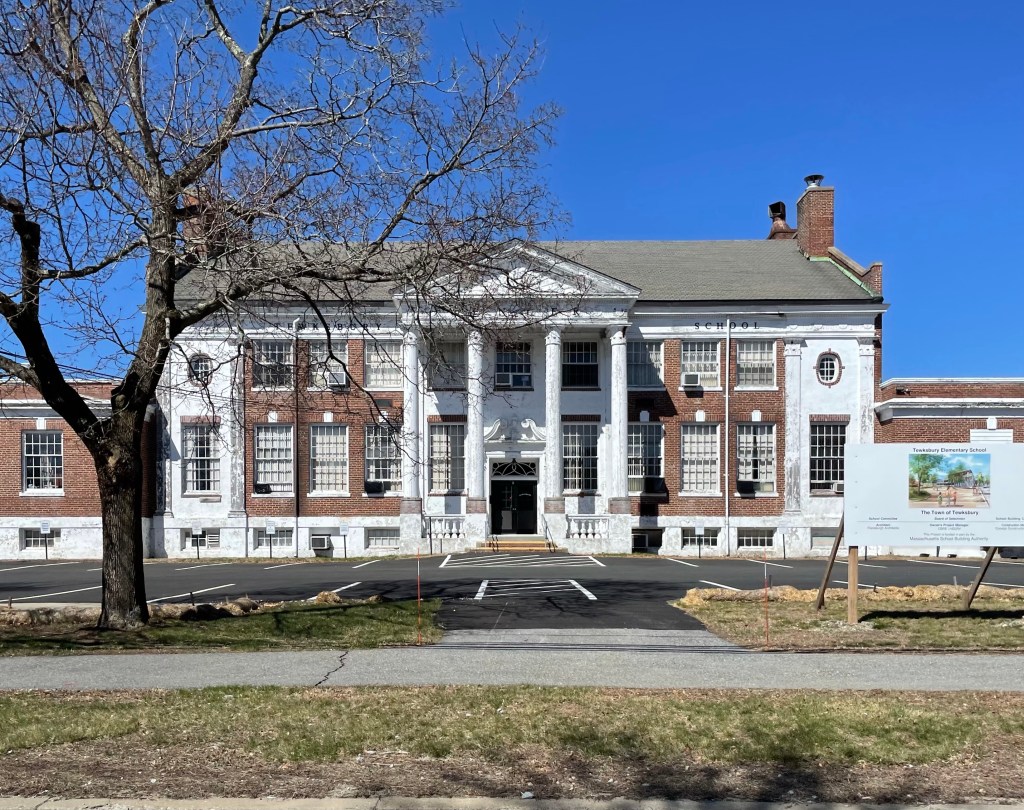
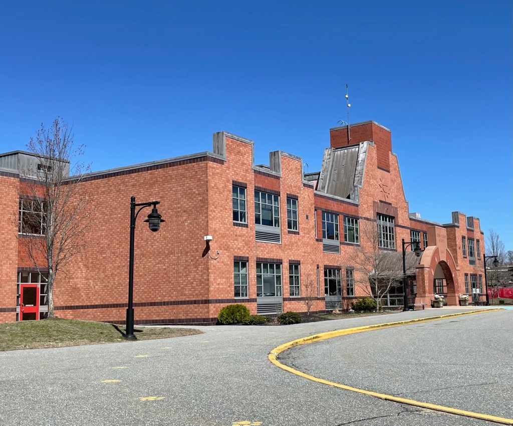
Built in 1934 as the fourth high school for the town of Tewksbury, this Neo-Classical school building has seen better days. The Center School was designed by Miller and Beal architects of Portland, Maine, and likely funded with assistance of New Deal program funding during the Great Depression. The next year, Tewksbury Stadium was dedicated in 1938, which was a Works Progress Administration (WPA) project. The Tewksbury Center School retains many of the details that characterize its Neo-Classical Style including: the front gable entry portico supported by two-story Corinthian columns and pilasters, the wide frieze band with the band of dentil molding, the decoratively clad end bays framed by Corinthian pilasters, the broken pediment of the door surround, and keystones in the brick lintels. The town needed to expand at the end of the 20th century, and hired Architectural Resources Cambridge to design the John F. Ryan Elementary School, located behind this building. The Ryan Elemetary School is a pleasing design which is Post-Modern in style. The Center School has been used as offices for the School Department and was recently proposed to be demolished for surface parking, and a new school constructed elsewhere on the site. This seems very wasteful, and epitomizes the lack of regard for environmental or historical conservation in many cities and towns.

Kneeland Street Station // 1847-1918

All Aboard!! The Kneeland Street Station was built at the southern edge of Downtown Boston in 1847 for the newly established Old Colony Railroad Company. By the early 1840s, the city of Boston had six major rail lines connecting it with other places including Lowell, Maine, Fitchburg, and Salem to the north, Worcester to the west and Providence to the southwest. The southeastern part of Massachusetts had yet to be served by a rail link to Boston. On March 16, 1844 the Old Colony Railroad Corporation was formed to provide a rail connection between Boston and Plymouth. Construction of the line began in South Boston in 1844 and the line opened to Plymouth in 1845. The company needed a more accessible station to the residents and businessmen of Downtown Boston, so they acquired a large parcel of land on Kneeland Street to extend the line. The corporation hired architect Gridley James Fox Bryant, who designed this stunning railroad station constructed of brick with strong stone trimmings. As was common, a large clock was affixed to the building to allow waiting passengers to know how long they would be waiting. From 1845 to 1893, the Old Colony railroad network grew extensively through a series of mergers and acquisitions with other established railroads, serving lines to Providence, Newport, Fall River, New Bedford and down the Cape. The railroad was acquired in 1893 by the New York, New Haven and Hartford Railroad, and sought to consolidate the many local stations into a larger building. They soon after began construction on Boston’s South Station, re-routing lines to that new building. They sold off the excess stations, including this one on Kneeland Street, and it was eventually demolished in 1918.

Beacon Hill Reservoir // 1849-1883

Did you know there was once a massive granite reservoir in Beacon Hill?

Long before the Wachusett and Quabbin Reservoirs that now supply water to Boston, the city’s original municipal water supply was Lake Cochituate, a reservoir in Metro-west. Due to Beacon Hill’s high elevation, the city selected the site behind the recently completed Massachusetts State House, to store and distribute water to the city. The site was too steep, so it had to be graded. Therefore, the top of Beacon Hill, where the beacon had long been standing, needed to be lowered to accommodate the reservoir. The soil was dug by hand and hauled by cart down to fill the old Mill Dam in the Bulfinch Triangle area. The reservoir, which opened in 1849, was unique in its approach. The design of the structure needed to minimize its footprint and reflect well on its surroundings in the prestigious location. In lieu of earthen bermed walls, as was the convention in most period distribution reservoirs, the design chose to create a watertight tank within a masonry structure. This made the structure the first elevated storage tank constructed in New England. Sheet lead was used to make the reservoir watertight (which likely led to a lot of health issues (hindsight is 20/20). By 1870, the poor water pressure made the Boston Waterworks build the Roxbury Standpipe, which relegated the Beacon Hill Reservoir to being an emergency water source for use only in case of fire or accident to the pumping-mains. In 1883, Boston Water Works sold the structure to the Commonwealth, who demolished it for the addition to the State House.

B. F. Keith’s Boston Theatre // 1894-1952

The other day, I was walking in Boston Common along Tremont Street, when I noticed this oddly ornate building wedged between larger, modern buildings. I HAD to investigate! The building was actually constructed as an arcade/covered walkway which ran to Mason Street behind, with a tunnel running under that street into the B.F. Keith’s Theatre. In 1892, Benjamin F. Keith and his business partner E.F. Albee purchased land off Mason Street, a scarcely trafficked street between the busy Tremont and Washington Streets in Boston’s Theater District, with the goal of creating the city’s finest vaudville theatre. The duo hired J. B. McElfatrick & Son, architects who specialized in theatres, to design the new B.F. Keith’s. Due to the site being wedged between two main streets, entrances were built off both Tremont and Washington with flashing lights and marquees, guiding patrons inward. The Tremont facade was especially grand so that B. F. Keith’s New Theatre could be advertised on, and approached directly from, Boston Common, with lights flooding the park. The theater opened in 1894 and was over-the-top with intricate details and sculpture all over, appealing to the city’s wealthy as a place to see the arts. Although it was primarily a vaudeville house during Keith-Albee’s ownership, famed inventor Thomas Edison demonstrated his new Vitascope movie projector here on May 18, 1896. This was the first projection of a movie anywhere in Boston. As live shows made way for motion pictures, the theater adapted, but suffered around the Great Depression when would-be patrons decided to save their limited money. In 1939, the theater was converted to a movie theater named the Normandie. The theater was demolished in 1952 for a surface parking lot to provide better service to the Opera House (originally B.F. Keith’s Memorial Theatre, confusing I know) and Paramount Theater. Today, all we have left of the once beloved B.F. Keith’s Theater is the small annex, which is virtually unrecognizable from historic images as most of its decoration and the top two stories were removed.

1906 image courtesy of Library of Congress.

Mount Pleasant House // 1875-1939

One of the earlier grand hotels in the White Mountains of New Hampshire, was Mount Pleasant House, built in 1875 after the arrival of the railroad through Crawford Notch. The hotel was located on a small hill where the Lodge at Bretton Woods is currently sited, across the street from the iconic Mount Washington Hotel. It was built by lumberman and investor John T.G. Leavitt and opened the following year. It was then a simple, almost box-like structure with only forty rooms, later expanded and “modernized” to accommodate the growing waves of affluent visitors from New York City and Boston every year. In 1881, Leavitt sold the hotel to Oscar Pitman and Joseph Stickney, the latter eventually became sole owner and acquired land across the street to build the Mount Washington Hotel in 1900. Possibly as a practice for his larger endeavor across the street, Stickney hired one of Portland’s leading architects, Francis H. Fasset, to design the additions and alterations. When Stickney died in 1903, just a year after his larger hotel was built, both properties were willed to his wife, Caroline. She ran the company through changing economic conditions and when she died, in 1936, the hotels were left to her nephew, F. Foster Reynolds. Reynolds decided that the Mt. Pleasant was not worth the expense needed to maintain it, and in 1939, ordered the building demolished, replaced decades later with the present building.

William G. Low House // 1887-1962

One of the many significant losses to American architecture is the demolition of the Low House, a perfect encapsulation of the Shingle style of architecture by one of the most prolific designers in American history. The William G. Low House was constructed at the southern tip of Bristol, Rhode Island by esteemed architect Charles Follen McKim (my personal favorite) of the firm McKim, Mead & White. The Shingle style, which took off in the Northeast United States, primarily in seaside communities in the late 20th century, the homes of the style often had a strong horizontal emphasis. The style contrasts the other Victorian-era styles, de-emphasizing applied decoration and detailing in favor of complex shapes wrapped in cedar shingles. The Low House, formerly located on Low Lane, stood out for its 140-foot long gable which appeared to protrude right from the hilly outlook. The home was demolished in 1962, but was documented by the Historic American Buildings Survey program, which documented the home inside and out before it was a pile of rubble. Architectural historian Leland Roth later wrote, “Although little known in its own time, the Low House has come to represent the high mark of the Shingle Style”.

“Hey Bonnie Hall” // 1808-1944

Formerly located on the Poppasquash Peninsula in Bristol, Rhode Island, the William DeWolfe House, also known as Hey Bonnie Hall, was constructed in 1808 for William DeWolf (1762-1829) and his wife Charlotte Finney (1764-1829). William DeWolf was a member of the infamous DeWolf Family of Rhode Island, which is believed to have transported tens of thousands of enslaved people to the United States and Caribbean before the African slave trade was banned in Rhode Island. The Ocean State played a leading role in the transatlantic slave trade. Not only did Rhode Islanders have slaves—they had more per capita than any other New England state. The beauty of Hey Bonnie Hall, and its melodic name hid the dirty money with which it was built. With his extreme wealth, William hired Providence architect Russell Warren to construct the home in a high form of the Federal style. Eventually, the home was willed to Anna DeWolf, who married Nathaniel Russell Middleton, from a slave-owning family in Charleston, South Carolina (birds of a feather…). It was Anna Middleton who gave the house its curious name of “Hey Bonnie Hall”. When she was younger, she used to sing an old Scottish song called “Hey The Bonny Breast Knots” over and over again to delight her grandfather, William, the first owner of this home. After Anna’s death, the home was willed to her two unmarried daughters. The Great Atlantic Hurricane of 1944 proved fatal for the grand estate, when the front portico was ripped off the home and flew away. The damage was deemed too expensive to repair and the home was demolished that year.

Goddard Mansion // 1859-1981

This shell of a former mansion was built in 1859 for Colonel John Goddard (1811-1870), a Civil War Union Army Officer. Goddard was a “lumberman” who amassed substantial wealth before the outbreak of the Civil War, and he hired architect Charles A. Alexander, to design an estate house for him and his family. The home appears to have been constructed of local stone with white granite trim and featured a prominent tower, emulating an Italian Villa. The home was purchased in 1898 by Judge Joseph W. Symonds, who presided over the Maine Supreme Judicial Court. Just two years later in 1900, during the expansion of Fort Williams, the estate was acquired by the Federal government. The home was used for housing married enlisted men and their families while stationed at Fort Williams. The basement was converted into the fort’s Non-Commissioned Officers’ Club. At the time of the town’s purchase of the Fort in 1964, the mansion was already in serious disrepair and its future was uncertain. People routinely broke in and damaged the interior, which suffered numerous small fires over the years, until the town decided in 1981 to hold a controlled burn of the home, leaving the shell. The shell remains a significant architectural landmark and a massive opportunity for the town.

Paragon Park // 1905-1984

The Nantasket area of Hull on Boston’s south shore had been a popular summer destination since the middle of the 19th century, when resort hotels were developed there to take advantage of the ocean breezes and sweeping vistas. Paragon Park, an amusement park developed at the turn of the century was a great addition to provide activities for the summer visitors and resident alike. Convenient transportation in the form of steamship service and an electric railroad from Boston added to the appeal of the area. The park developed rapidly over the early 20th century and featured rides, activities and shows. The park was thought to be a mini World’s Fair, featuring a lagoon at the center with small boats to ride, and new expositions and features added every summer. The park struggled in the second half of the 20th century as the land value was more expensive and the park was only open a couple months a year. It sold in 1984 to developers who sold off many features and demolished almost all of the structures. The Giant Coaster, built in 1917 was one time, the largest roller coaster in New England. When the park was purchased, the roller coaster was sold to Six Flags America near Washington D.C. and is now The Wild One.

Hull Yacht Club // 1891-1930s

c.1891 image of second Hull Yacht Clubhouse, Stebbins Collection, HNE

In the Spring of 1880, thirteen Hull, Massachusetts, summer residents, who owned and raced small sailboats, met and decided to form a yacht club. The Hull Yacht Club was founded that same year. During the first two seasons there was no club house, sailing events were run from a private pier and dock and meetings were held at members homes. Even though they started with no club house, being close to Boston with plenty of deep, protected water, drew many new members. The first clubhouse here was constructed in 1882 and the club saw membership soar to over 500. The clubhouse was quickly deemed inadequate for the Boston-area elite and their massive sloops. The second Hull Yacht Club was completed in May 1891. The New York Times and Outing Magazine described the new club as one of the grandest yacht clubs in America, and at the time, it had the second highest membership in the country! The main club house was designed by architect S. Edwin Tobey, and stood four stories, with a 12 foot wide piazza on three sides covered by endless expanses of shingles. The third floor had billiard rooms and public and private dinning, committee room, reading room, wine room, The second floor housed three bowling alleys, and the first floor had lockers, showers, laundry, spar storage. The club merged a couple times over the subsequent decades, but suffered heavily due to the Great Depression, when the Gilded Age monies stopped flowing as freely. The club sold the massive shingled building to developers who sought to convert the building into a resort, but it was deemed a fire hazard and razed in the 1930s. The club erected a new, modest clubhouse near Point Allerton later.

Fort Revere // 1898-1947

Fort Revere, named in honor of Paul Revere, was acquired as Nantasket Head Military Reservation in 1897 under the large-scale Endicott program, which initially included seven forts in the Harbor Defenses of Boston. The fort replaced the outdated Revolutionary-era fortifications and built upon the earthworks, creating batteries were built 1898–1906. Additionally, a 1903 concrete water tower was constructed to provide water and reconnaissance to the fort. After the American entry into World War I in early 1917, the fort was expanded to include temporary structures such as quarters and additional storehouses. With the outbreak of World War II in 1939, Fort Revere was again built up with temporary structures to accommodate the 1940–1941 mobilization. With new defenses completed elsewhere in the Boston area, the fort’s remaining original guns were scrapped in 1943. After the war, Fort Revere was disarmed and turned over to the Commonwealth of Massachusetts. Remains of Fort Revere include six gun emplacements built into the southeast, east and north sides of Telegraph Hill. They are connected by dugouts or bunkers and are of concrete and brick construction. Additionally, tunnels and storerooms can be explored, lined with graffiti and crumbling concrete. I highly recommend you all check it out and explore the grounds, its a great place to explore and learn history! Fingers crossed to see the remaining fortifications restored to their former glory.

Isabella Stewart Gardner Townhouse // 1860

152 Beacon (center) and 150 Beacon (right) demolished. Courtesy of Boston Athenaeum.

In 1860, David Stewart, a merchant from New York, built a townhouse on Beacon Street in Boston’s Back Bay neighborhood as a wedding present for his twenty year old daughter, Isabella Stewart, and her new husband, John (Jack) Lowell Gardner. The house was originally numbered 126 Beacon, but re-numbered as 152 Beacon ca. 1862 when homes were built on the south side of the street. The home was the city dwelling of the young couple, who also owned “Green Hill” in Brookline, and an estate on the North Shore. Isabella Stewart Gardner began amassing a large collection of art and their Back Bay home was insufficient to display it all. In 1880, John purchased the neighboring home at 150 Beacon from Andrew Robeson, a wealthy merchant from Fall River, whose main home is now the headquarters of the Fall River Historical Society. Soon thereafter they combined the two houses, with the address of 152 Beacon, to provide greater space for the display of the growing art collection being assembled by Isabella. After her husband’s death in late 1898, Isabella Gardner pursued plans for a new home that would provide a suitable setting for her art collection. She purchased land in the Fenway and began construction on her mansion, Fenway Court, now the Isabella Stewart Gardner Museum. One year after completion of Fenway Court, the two townhomes were purchased by Eben Draper, who razed them for his mansion in 1904 (see last post).

Commonwealth Trust Company // 1908-c.1974

Ca. 1910 image courtesy of Boston Public Archives.

Located at the corner of Summer and Devonshire Streets in Downtown Boston, the Commonwealth Trust Company’s two-story marble banking house commanded the corner, despite its short stature. The building, completed in 1908, was constructed with Lee marble and decorated with ornate wrought and cast-iron grilles over windows. The building was designed by the architectural firm of Parker, Thomas & Rice in the Classical mode with large, fluted Corinthian columns and boxed corner pilasters framing the recessed center entrance, Corinthian pilasters ran along the side facade. At the inside, the building was coated with Cararra and Blanco marble with paneled oak offices. At the ground floor, offices and banking stations framed the outer walls, with the safety deposit boxes located on the second floor. The building was demolished by the 1970s and replaced with a one-story minimalist Modern building (I could not figure out why the former building was razed). The new building was demolished after a few decades with a larger building, better fitting the commercial district.

Old Penn. Station // 1910-1963

Pennsylvania Station in Manhattan was opened in 1910, and its sheer scale immediately evoked a sense of awe. At the time it was completed, it was the largest building ever built occupying two entire city blocks, and boasted the biggest waiting room in history. Over 500 buildings were demolished for the station to make way for the Charles McKim-designed station, an icon in the Beaux-Arts style. The structure had “nine acres of travertine and granite, 84 Doric columns, a vaulted concourse of extravagant, weighty grandeur, classical splendor modeled after royal Roman baths, rich detail in solid stone, and an architectural quality in precious materials that set the stamp of excellence on a city.” Sadly, being one of the most beloved architectural gems in the city did not constitute its maintenance nor preservation.

In 1961, after numerous plans for redevelopment, air-rights were sold on the building and in 1963, Penn Station was razed. The former grand station was replaced by Madison Square Garden and Pennsylvania Plaza, an office skyscraper, all with a modernized station below. When the building was destroyed, art historian Vincent Scully famously said, “One entered the city like a god. One scuttles in now like a rat.” In 1965, two years after Penn Station’s demolition commenced, the city passed a landmarks preservation act, thereby creating the New York City Landmarks Preservation Commission. Additionally, Grand Central Station was proposed to be demolished later in the decade, but was saved thanks to preservation efforts.

Waban Station // 1886-1958

Image from Harvard Archives.

The village of Waban in Newton, Massachusetts, was named after a Massachusett Chief who had previously resided atop Nonantum Hill on the Newton-Brighton line. This location is believed to have been a favorite hunting ground for Waban (the Wind) and his people. Throughout much of the 19th century, Waban remained a quiet agricultural region. As late as 1874, fewer than 20 families held title to all of its land. In the mid-1880s, however, interest in suburban developments near the Boston and Albany Railroad became increasingly widespread. Seeing suburbanization in the late 19th century and into the early 20th century.

The station that allowed all the development in the early days of Waban was built in 1886. The Boston & Albany Railroad hired renowned architect Henry Hobson Richardson to design the station, and many others on branches of the various lines radiating out from Boston. The Highland Branch (which this station was on) was later acquired by the MBTA in Boston, which operated it as a Commuter line. Waban Station closed along with the rest of the Highland Branch commuter rail line in 1958 and reopened a year later in 1959 as part of the Green Line’s D Branch. The gorgeous H.H. Richardson-designed station was demolished in order to build a 74-space parking lot. They literally paved paradise, and put up a parking lot